Start: 01/01/2014
End: 31/12/2014
Funding: Catalan, Industrial
Status: Completed
End: 31/12/2014
Funding: Catalan, Industrial
Status: Completed
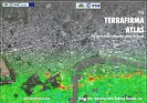
Acronym: TERRAFIRMA
Terrafirma is a research project led by Altamira Information (Spain) with the participation of the German Aerospace Center (DLR, Germany), Gamma Remote Sensing (Switzerland), Hansje Brinker (The Netherlands), Fugro NPA (UK), Tele-Rilevamento Europa (TRE, Italy), Harokopio University of Athens (HUA, Greece), IREA (Italy), British Geological Survey (BGS, UK), Danish Technical University (DTU, Denmark), Deltares (The Netherlands), DMT (Germany), Federal Institute for Geosciences and Natural Resources (BGR, Germany), Federal Office for the Environment (Switzerland), Geological Survey of Denmark and Greenland (Denmark), Geological Survey of The Netherlands (TNO, The Netherlands), Instituto Geológico y Minero de España (IGME, Spain), Università degli Studi di Firenze (UNIFI, Italy), Stamatopoulos and Associates (SAA, Greece), European Federation of Geologists (Belgium), the former Institute of Geomatics (IG, Spain) and Instituto Nazionale di Geofisica e Vulcanologia (INGV, Italy). Terrafirma is funded by the European Space Agency’s (ESA) Global Monitoring for Environment and Security (GMES) Service Element Programme.
Terrafirma provides a ground motion hazard information service, distributed throughout Europe via national geological surveys and institutions. The objective of this service is helping to identify hazards, improve safety and mitigate risk.Terrafirma is based upon the revolutionary remote sensing technique of Persistent Scatterer Interferometry (PSI) which has the power to map millimetric ground motion phenomena from space. PSI involves the processing of 50+ radar scenes from an archive dating back to 1991 to identify networks of reflecting ground features, such as buildings, bridges and other structures, against which precise phase measurements can be made over time. The results provide unique, wide-area maps of ground and building motion that can be difficult if not impossible to detect by conventional means. The service focuses on urban subsidence, landslides, earthquake zones, coastlines and flood plains.Terrafirma is operating in three discrete stages of 0-2, 2-5 and 5-10 years. The first two-year Stage 1 (which ended in 2005) concerned consolidation of both service providers and users. In November 2005 Terrafirma entered Stage 2, concerned with rolling-out the service across all Member States of the European Commission. During this stage, processing equally covering all of the EU 25 Member States was conducted along with the processing of seven landslide products within Greece, Italy and Switzerland. Stage 3 began in December 2009 and will continue until the end of 2012. This third and final stage offers services under the thematic lines of Coastal Lowland Subsidence & Flood Defense, Hydrogeology and Tectonics and offers a new Wide Area Service.The Geomatics division contribution to Terrafirma is related to the quality, validation and exploitation of the DInSAR and PSI products. The IG was the coordinator of the Terrafirma Validation Project, which focused on process and analyses of PSI deformation monitoring products generated within the GMES Terrafirma project.
• Altamira Information (Spain)
• German Aerospace Center (DLR, Germany)
• Gamma Remote Sensing (Switzerland)
• Hansje Brinker (The Netherlands)
• Fugro NPA (UK)
• Tele-Rilevamento Europa (TRE, Italy)
• Harokopio University of Athens (HUA, Greece)
• IREA (Italy)
• British Geological Survey (BGS, UK)
• Danish Technical University (DTU, Denmark)
• Deltares (The Netherlands)
• DMT (Germany)
• Federal Institute for Geosciences and Natural Resources (BGR, Germany)
• Federal Office for the Environment (Switzerland)
• Geological Survey of Denmark and Greenland (Denmark)
• Geological Survey of The Netherlands (TNO, The Netherlands)
• Instituto Geológico y Minero de España (IGME, Spain)
• Università degli Studi di Firenze (UNIFI, Italy)
• Stamatopoulos and Associates (SAA, Greece)
• European Federation of Geologists (Belgium)
• Instituto Nazionale di Geofisica e Vulcanologia (INGV, Italy)
Michele Crosetto
Researcher
Oriol Monserrat
Researcher
Guido Luzi
Researcher
María Cuevas-González
Researcher
No results found
No results found