End: 31/12/2013
Funding: European
Status: Completed
Acronym: SUBCOAST
Code: 242332
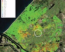
The main objective of SubCoast is to develop a user-centred downstream GMES-service for delivering data and information on extent and impact of subsidence in coastal lowland areas around Europe and demonstrate its viability in various pilot services for a variety of geographical settings and applications.
The service will be designed to appropriately determine the effects of subsidence on current and future floodrisk in coastal lowlands, monitor the integrity of coastal barrier systems and infrastructure and assess the impact of subsidence due to natural or man-made causes (groundwater pumping and oil/gas production) on land use and hydrology. SubCoast is built on the heritage of GMES Service Element “Terrafirma” and use the full capacity of PS-InSAR as an earth observation technology for large scale subsidence mapping. Necessary R&D will be focused on possible augmentation of data sources and the improvement of retrieval algorithms. Subsequent validation efforts will make full use of the Terrafirma Validation Testsite and other current validation initiatives. A distributed data and information system will be set up, which facilitates the accessibility and operability of EO-data, in-situ data (including geoscientific data) and model results for the selected areas. SubCoast will orient its services along existing guidelines established in previous GMES-projects, notably “Terrafirma”, and in line with relevant directives at European Level. End-user involvement will be realised by establishing a user federation which holds the most directly involved regional, national and European stakeholders.
OTHER PARTICIPANTS
• Nederlandse Organisatie voor Toegepast Natuurwetenschappelijk Onderzoek (TNO, The Netherlands)
• British Geological Survey (BGS, UK)
• Fugro NPA Ltd. (UK)
• Hansje Brinker (The Netherlands)
• Tele-Rilevamento Europa (TRE, Italy)
• Delft University of Technology (The Netherlands)
• Geological Survey of Denmark and Greenland
• Polish Geological Institute
• Lithuanian Geological Survey
• Deltares (The Netherlands)
• Alma Mater Studiorum – Università di Bologna (Italy)